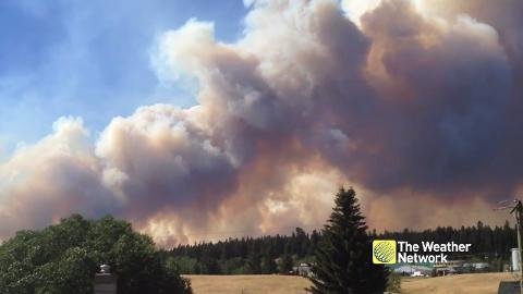
Interactive: Map provides information about all active B.C. Forest fires
Click here for the Wildfire Map!
There are three major wildfires burning in the area of Williams Lake on Saturday.
A 1,000-hectare fire is burning in the Wildwood area/Williams Lake Airport (YWL), which is just north of Williams Lake. It is zero per cent contained at this time. The cause of the fire is under investigation.
http://firesmoke.ca/forecasts/BSC00WC04/current/
The Williams Lake Airport remains closed to commercial and private aircraft. It is open to firefighting crews only.
The Chief William fire, located at 150 Mile House, which is just south of Williams Lake, is estimated to be about 2,000 hectares in size. It is zero percent contained at this time.
Finally, the Spokin Lake Road Fire, burning near Spokin Lake, which is located approximately 20 kilometres east of Williams Lake, is about 100 hectares in size. It is also zero percent contained.
Hundreds of homeowners have been evacuated due to these fires.
100 Mile House (Gustafsen wildfire):
The Gustafsen wildfire, is burning near the Gustafsen North Forest Service Road, just west of 100 Mile House. It is currently estimated to be 3,200 hectares in size but smoke being generated by the fire is making it difficult to ascertain its exact size. It is zero per cent contained.
Thousands of people have been forced from their homes due to this aggressive wildfire.
Princeton:
A wildfire burning 10 kilometres northeast of Princeton is estimated to be 1,500 hectares in size and is zero per cent contained.
A mandatory Evacuation Order now includes 60 total properties. The order includes Highway 5A between Summers Creek Road and Dry Lake, approximately 10 kilometres north of Princeton and the first 20 kilometers of Summer Creek Road.
Ashcroft:
A wildfire estimated to be 4,000 hectares in size is burning near Ashcroft.
Structures have been impacted by this fire but officials say due to poor visibility, it is not possible at this time to determine the number of structures that have been affected.

Smoke is visible from Highway 97C.
The wildfire has prompted an evacuation order for the entire village of Cache Creek.
Ashcroft Hospital has also been temporarily closed.
Thousands forced to flee as over 150 wildfires rage in B.C. - The Weather Network

Hi! I am a robot. I just upvoted you! I found similar content that readers might be interested in:
http://globalnews.ca/news/3585149/photos-wildfires-burning-around-b-c/