The Introduction to Remote Sensoration - Basic Concepts
Hello everyone ...
Welcome to my introduction to the Remote Sensoramiento, this satellite tenant that is currently used by geodetic engineers as well as scientists for the study of satellite images, it should be noted that in my professional area I am doing a lot with this technique and that is part of my daily work, configure all the satellite images obtained, today I started with this introduction to refer to important elements in the study of remote sensing, such is the case, that here you can know information, as is the assessment remote? , basic elements of this technique, as well as objectives that it presents in function to the knowledge used in the study area.
Now without further words, I just have to make the invitation to discover this magical world of remote sensing, in which it is very broad and at the same time very didactic for all of us, below "The Introduction to Remote Sensoration - Basic Concepts".
The principle of remote sensing is based on the notion of the electromagnetic spectrum, since they measure the energy that is reflected or emitted by the elements that make up the earth's surface such as rocks, soil, vegetation, water, etc., as well as those of origin anthropic (urban constructions, communication routes, etc.), without coming into contact with them.

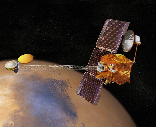
Imagen Source (The Mars Odyssey used spectrometers and images to look for evidence of past or present water and volcanic activity on Mars):wikimedia.org
Basic elements of a remote sensor system
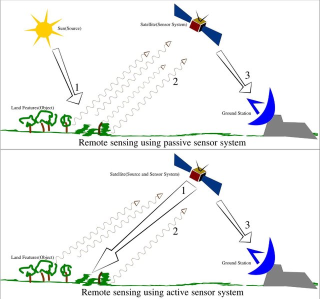
- Energy source, it can be the energy emitted by the sun or emitted by the same sensor.
- Propagation of energy through the atmosphere.
- Retransmission of energy through the atmosphere.
- Land cover, which constitutes the land surface and its components such as the atmosphere.
- Sensor system, composed of a sensor is the one that captures the light coming from the elements of the surface, and the platform that sustains it.
- System of reception and commercialization, receives the information, records it in an appropriate format and then distributes it.
- Interpret, analyze in a visual and digital way, and convert into a thematic or quantitative key.
- Field support, consists in the verification or rectification of the data processed by the interpreter (terrestrial validation).
- End user, in charge of analyzing the document and making decisions.

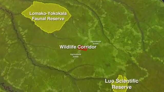
Image source (This video is about how Landsat was used to identify conservation areas in the Democratic Republic of the Congo and how it was used to help map an area called MLW in the north):wikimedia.org
Type of Remote sensors
The sensors, according to the region of the spectrum where they operate, can be classified as microwave, Visible. Infrared; and according to the type of energy used in assets and liabilities.
Active perception systems Active perception systems generate a signal, bounce off an object, and measure the characteristics of the reflected signal. An example of this type of perception is RADARSAT (Canadian satellites). Radio waves are emitted by a transmitter and are picked up by a receiver after they have been reflected by an object. Reflected signals can be used by RADAR systems to determine the distance and direction of perceived objects. You can also create images of the objects.
Passive perception systems currently the images created by passive perception systems are of greater value in the applications of remote perception in agricultural production. Passive systems simply receive the signals emitted naturally and reflected by the perceived objects. These signals, generated by natural solar radiation, can provide very rich information about perceived objects. Example of this type of sensors Landsat, Spot and Ikonos, among others.
Microwave sensors, the first experiments performed with this type of sensors were performed by astronauts on board the SKYLAB in 1974. The GEOS-3 demonstrated the feasibility of using high resolution altimeters to monitor the state and mean sea level. In addition, on the NIMBUS 5 and 6 they flew scanning radiometers. The synthetic aperture radars had been flying only in airplanes. SEASAT took them all together for the first time.
Infrared sensors, the first set of repetitive observations of the sea surface taken from satellites was the temperature. The AVHRR flew first in the TIROS-N in 1978 and has generated a continuous series of measurements since that time.

Image source(Remote sensing illustration):wikipedia.org
Resolution of the data acquired by remote sensors
Spatial resolution refers to the size of the smallest object that can be distinguished in an image produced by a remote sensor. If the remote images are going to be used to identify and deal with problems of cultivation in the field, the interpreter must consider how finely tuned an image should be to allow him to discern what is happening in the study area.
Spectral resolution refers to the ability of perception systems to distinguish and differentiate between electromagnetic radiation of different wavelengths. This is basically a measure of the ability of a system to concentrate on detecting a particular wavelength that is of interest. For example, some sensors produce so-called panchromatic images. These images are created from the radiation perceived within the spectral band between 0.45 and 0.90 μm. Within this band are blue, green, red and near infrared. These bands are of particular interest in plant production. The higher the spectral resolution within the green and near infrared, the more useful the information that can be deduced from remotely sensed data will be.
Temporary Resolution a measure of how often a remote sensing system is available to collect information from a specific point on earth. For most satellites, the frequency of coverage for any particular site is equal to the repetition cycle, or the duration in time it takes to go around the earth. However, some satellites have the ability to direct the sensor (s) so that an area of interest can be seen several times in a single repetition cycle.
Radiometric Resolution is the ability of a sensor to record small energy changes. It is measured in number of gray levels or digital accounts.
Remote sensing applications
Conventional radar is mainly associated with air traffic control, early warning and certain large-scale meteorological data. Doppler radar is used by local authorities that monitor speed limits and improved weather collection, such as wind speed and direction within meteorological systems, as well as the location and intensity of precipitation. Other types of active collection include plasmas in the ionosphere. Synthetic interferometric aperture radar is used to produce precise models of large-scale digital terrain elevation (see RADARSAT, TerraSAR-X, Magellan).
Laser and radar altimeters on satellites have provided a wide range of data. By measuring the water bumps caused by gravity, they map the features on the seabed to a resolution of a mile or so. When measuring the height and wavelength of ocean waves, altimeters measure wind speed and direction, and surface ocean currents and directions.
Ultrasound (acoustic) and radar gauges measure sea level, tides and wave direction in coastal and offshore tide gauges.
The detection and range of light (LIDAR) are well known in examples of location of weapons, location of projectiles illuminated by laser. LIDAR is used to detect and measure the concentration of various chemicals in the atmosphere, while aerial LIDAR can be used to measure the height of objects and features in the ground more accurately than with radar technology. Remote vegetation detection is a main application of LIDAR.
Radiometers and photometers are the most common instrument in use, which collects the reflected and emitted radiation in a wide range of frequencies. The most common are visible and infrared sensors, followed by microwaves, gamma rays and, rarely, ultraviolet. They can also be used to detect the emission spectra of various chemical products, providing data on chemical concentrations in the atmosphere.
Stereographic pairs of aerial photographs have often been used to make topographic maps by images and terrain analysts in transit departments and roads for potential routes, in addition to modeling the characteristics of terrestrial habitat.
Simultaneous multispectral platforms such as Landsat have been in use since the 1970s. These thematic mappers take images at multiple wavelengths of electromagnetic (multispectral) radiation and are generally found on Earth observation satellites, including (for example) the Landsat program or the IKONOS satellite. Maps of land cover and land use from the thematic mapping can be used to search for minerals, detect or monitor land use, detect invasive vegetation, deforestation and examine the health of native plants and crops, including agricultural regions or entire forests. Regulatory agencies, such as KYDOW, use Landsat images to indicate water quality parameters, including Secchi depth, chlorophyll a density and total phosphorus content. Meteorological satellites are used in meteorology and climatology.
Hyperspectral images produce an image in which each pixel has complete spectral information with images of narrow spectral bands in a contiguous spectral range. Hyperspectral imaging generators are used in a variety of applications, including mineralogy, biology, defense and environmental measurements.
In the field of combating desertification, remote sensing allows researchers to monitor and monitor long-term risk zones, determine desertification factors, help decision-makers define relevant measures of environmental management and assess its effects.
Geodesic
- Geodetic remote sensing can be gravimetric or geometric. Data collection by gravity was used for the first time in the detection of aerial submarines. These data revealed minimal disturbances in the gravitational field of the Earth that can be used to determine changes in the Earth's mass distribution, which in turn can be used for geophysical studies, such as in GRACE. The geometric remote perception includes images of position and deformation using InSAR, LIDAR, etc.
Acoustic and almost acoustic
Sonar: sound passive, listening to the sound produced by another object (a container, a whale, etc.); sound active, emitting pulses of sounds and listening to echoes, used to detect, measure distances and measurements of objects and underwater land.
Seismograms taken in different places can locate and measure earthquakes (after they occur) by comparing the relative intensity and the precise times.
Ultrasound: Ultrasound sensors, which emit high frequency pulses and listen to echoes, which are used to detect water waves and water levels, as in tide gauges or to tow tanks.
To coordinate a series of large-scale observations, most detection systems depend on the following: location of the platform and orientation of the sensor.High-end instruments now often use positional information from satellite navigation systems. Rotation and orientation are often provided within a degree or two with electronic compasses. Compasses can measure not only the azimuth (ie, magnetic north degrees), but also the altitude (degrees above the horizon), since the magnetic field is curved on Earth at different angles at different latitudes. The more accurate orientations require gyro-assisted guidance, periodically realigned by different methods, including star navigation or known landmarks.
Training and education to Remote Sensing
In most universities, remote sensing is associated with the departments of Geography. Remote sensing has an increasing relevance in the modern information society. It represents a key technology as part of the aerospace industry and has an increasing economic relevance: new sensors, p. TerraSAR-X and RapidEye are constantly developing and the demand for skilled labor is constantly increasing. In addition, remote sensing greatly influences daily life, from meteorological forecasts to reports on climate change or natural disasters. As an example, 80% of German students use Google Earth services; Only in 2010, the software was downloaded 100 million times. But studies have shown that only a fraction of them know more about the data they are working with. There is a large knowledge gap between the application and understanding of satellite images. Remote sensing only plays a tangential role in schools, regardless of political demands to strengthen support for teaching on the subject. Much of the computer software developed explicitly for school lessons has not yet been implemented due to its complexity. In this way, the subject is not integrated at all in the curriculum or does not pass the step of an interpretation of analog images. In fact, the issue of remote sensing requires a consolidation of physics and mathematics, as well as competencies in the fields of media and methods, in addition to the mere visual interpretation of satellite images.
Many teachers have a great interest in the subject "remote sensing", motivated to integrate this subject into teaching, whenever the curriculum is considered. In many cases, this stimulus fails due to confusing information. To integrate remote sensing in a sustainable way, organizations such as EGU or digital earth encourage the development of learning modules and learning portals (eg, FIS - Remote Sensing in School Lessons or Landmap - Spatial Discovery) promoting media and methods, as well as working.
Below is a video of the ESA Echoes in Space - Land: Introduction to Radar Interferometry (Remote Sonsoration)
Bibliography :
Getis, A., J. Getis, and J.D. Fellman, 1998. Introduction to geography. 5th edition, Wm.C. Brown Publishers, at Times Mirror Company, Dubuque, IA. USES. 517 p.
Jensen, J.R., 1996. Introductory Digital Image Processing: a remote sensing perspective. 2nd edition, Prentice-Hall, New Jersey, 316 p.