SEC | S20W6 : The Use of Drones in Agriculture
Hello everyone, it's never too late to participate, as long as the deadline still exists. It's great that I can try to give my opinion and learn about the theme in Week 6, hopefully, this will be an interesting post.
Speaking of drones, it is said that drones have been around for a long time and are functioning to suit their needs at that time. Finally, this unmanned aircraft developed rapidly in the early 2010s until now, its function is growing and used for various needs and uses. According to some websites I read, drones were first invented by Abraham Karem, at that time was still the Drone was still known as the Unmanned Aerial Vehicle (UAV).
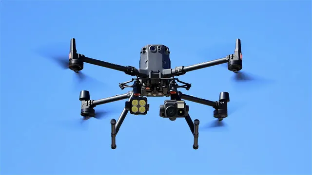
As time goes by and technological advances continue to grow, drones are not only used for tools of war, mapping tools, and so on. Drones are currently also utilized and used in agriculture with appropriate utilization as needed and are considered to have greater benefits.
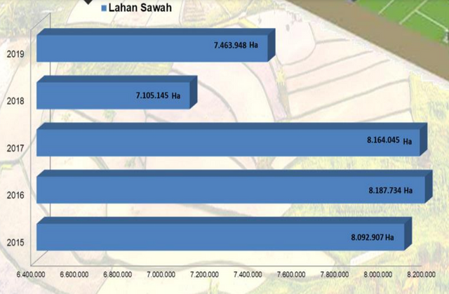
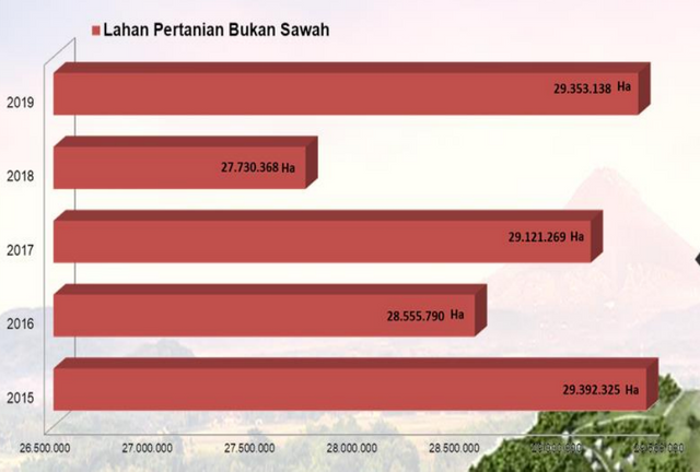
In Indonesia according to official data from the Central Statistics Agency (BPS) in the last year of 2019, the total area of paddy fields and other agricultural lands looks quite large, here are the detailed data
:
With the land area of the data above, is the use of drones in Indonesia in agriculture also large? Here is my brief description.
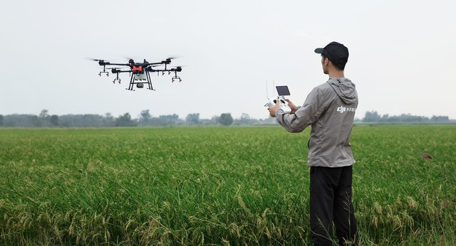
In Indonesia, the use or modernization of drones in Indonesia in agriculture is still relatively little used, especially in agricultural land managed by the state. But in agriculture managed by the private sector, the use of drones has indeed begun to be used, even then by millennial farmers who can operate spraying equipment using drones, or maybe mapping land using drones as a tool in agriculture.
In Indonesia, agricultural land and agricultural sector drivers are still carried out by rural communities. The number of farmers is decreasing every year, because the current generation is more inclined to engage in a much more modern business, and is not in the mood to continue agriculture business. So that the driving force in the agricultural sector is still dominated by those who have entered old age and are far from understanding technology, so drone technology can be said to be still difficult to reach by farmers in rural areas. Not to mention the Drone tools used are still quite expensive, and this is a problem why the use of drones is relatively small in Indonesian Agriculture.
The development of drones as one of the agricultural tools does have considerable benefits when viewed in terms of time efficiency, spraying technology in agriculture is one promising example that provides considerable efficiency. This will certainly increase the productivity of sustainable agricultural products, to support the needs of Natural Resources in the form of food that continues to increase every year.
The use of drones is not only used for spraying plants, drones can also be used as a tool for mapping land used by farmers efficiently and accurately. In addition, drones can be fertilization aids, with a way of working that is almost the same as other spraying. And no less important, drones can also be used as a tool to see the condition of plants from pests, as well as monitor crop irrigation needs.
In its development, drones are also modified into tools that monitor soil moisture and nutrient levels in plants. However, this certainly requires much larger funds, because it requires a multispectral or thermal camera tool that is used to obtain this information.
It is undeniable that by using drones equipped with multispectral or thermal, can help farmers easily make decisions or identify soil moisture and nutrient levels in plants used by farmers.
As far as I know and understand, multispectral and hyperspectral sensors can see and distinguish the soil surface, identify and characterize the materials contained in the soil, can deduce the biological and chemical processes on the land. What is even more remarkable is that it can detect areas that are likely to be at risk of forest fires or have the potential to experience forest fires. Based on the benefits obtained from multispectral and hyperspectral imaging sensors, drones by utilizing these technologies are very important for farmers if they can be used.
The biggest problem as I mentioned above, is that the price to use the device is still relatively expensive for farmers, especially farmers who are in the countryside.
In certain fields and one of them is agriculture, soil mapping is important. With the mapping done, it is expected that there will be sufficient availability of agricultural land for farmers to provide an overview of the initial planning before starting farming.
Soil mapping is also indispensable for precision agriculture, where the agricultural system requires a management strategy. This is to optimize all use of resources to the maximum, to increase the yield of Agriculture to the maximum, as well as to reduce the negative things that often have an impact on the environment.
Thus, the actual use of drones in agriculture is very important to be able to increase agricultural yields that are much more efficient and planned with all the uses that can be utilized. However, insufficient knowledge and still high prices of drones and other supporting technologies, make this the biggest obstacle for farmers, especially farmers in Indonesia.
That's how I publish this simple post, greetings to all of you.
| Period | 20 July to 20 October, 2024 |
|---|---|
| Transfer to Vesting | 1,127.282 Steem |
| Cash Out | 0 Steem |
| Result | Club100 |
| CSI | 15.2 (0.00 % self, 105 upvotes, 93 accounts, last 7d) |

Upvoted. Thank You for sending some of your rewards to @null. It will make Steem stronger.
Welcome to the agro-learning challenge season 20.
Observations and suggestions:
. Good explanation but deviated from the question asked. This is not all about the challenges or problems of drone use or adoption. However, presenting us with more modernization results in agriculture would have been ideal. Crop monitoring, precision application, diseases/pest management, labour/time efficient management, etc are some of the areas drones has aided modernization in agriculture.
. Considerably good explanation of other questions asked. Thank you also for the good post-presentation.
. We appreciate your participation and hope to see you more in our learnings.
Thanks for the input as well as the verification, it really helps. Success is always for you, and have a nice day.
Postingan yang sangat informatif, semoga anda sukses dalam kontes ini
Terima kasih ibu dewirusli, dukungan anda sangat berarti.
Wow sepertinya ini sesuatu yang baru uang harus di coba
Terima kasih pak.
siap pak ketua