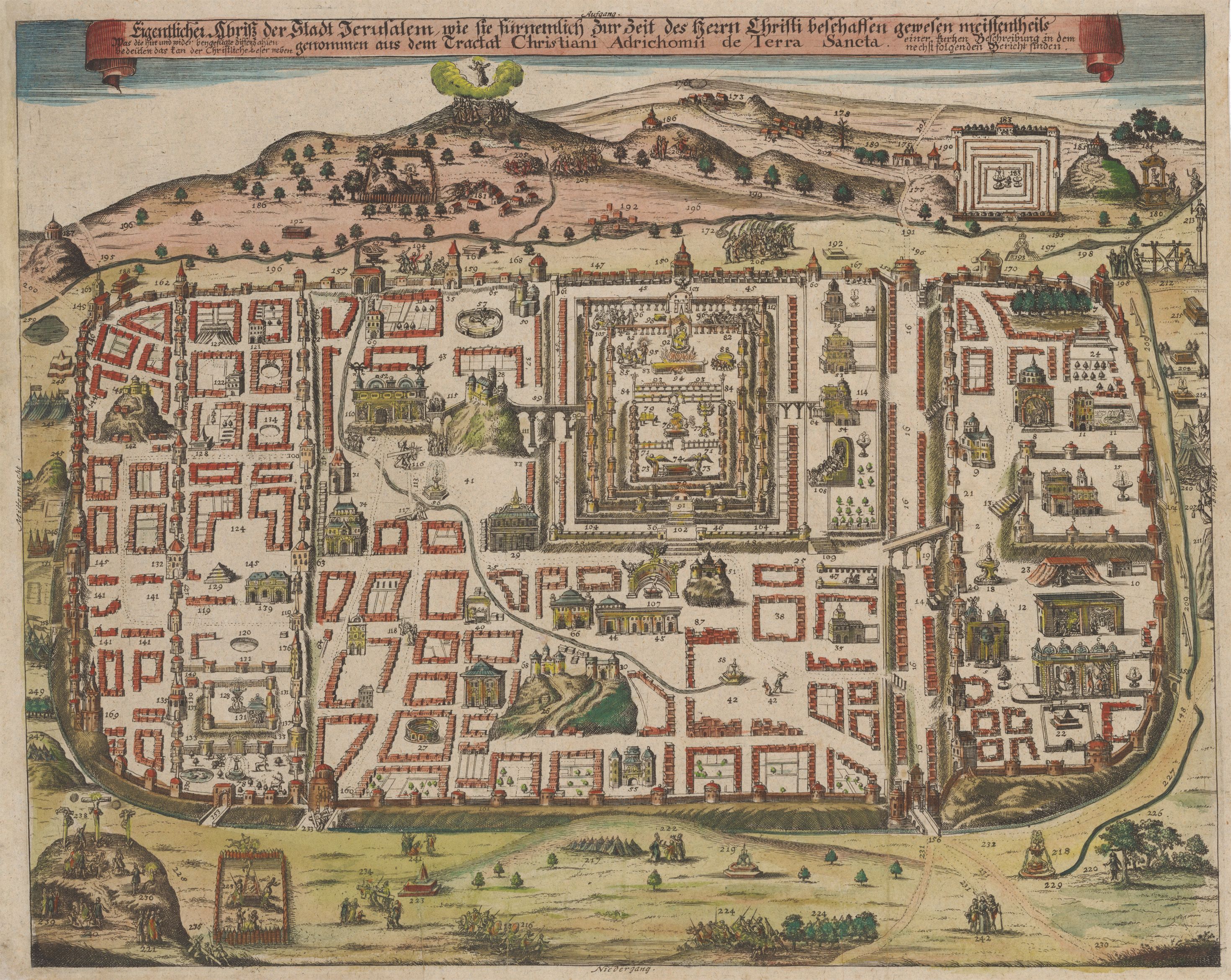
1708 Map of Jerusalem focuses on the life of Jesus Christ as told through the new testament.

Eigentlicher Abriss der Stadt Jerusalem...
By: August Christian Fleischmann
Date: 1708 (circa) Nuremburg
Dimensions: 13.5 x 16.75 inches (34.3 cm x 43 cm)
This marvelous map shows Jerusalem as it was in antiquity. Based on the 1584 map of Christian van Adrichems, it was engraved by Fleischmann in 1708. The map provides an intimate view of the ancient city, showing buildings such as temples, churches, basilicas, aqueducts, the city walls, walls of villas, many walls within walls, all with towers intact. Also depicted are fortresses, housing districts, fountains, arenas and a colosseum for games, aqueducts, and both domesticated stock and wildlife. It is peopled with tiny lively figures engaged in all the activities of day-to-day life. The interior of the Temple is detailed, with the Ark of the Covenant along with other holy objects in the Temple’s holy of holies, and we see Christ chasing the money lenders from the temple. Many sites of biblical significance are depicted within the city walls.
Outside the city walls we see hilltop temples, pagan shrines with worshippers at one shrine, a luxurious estate, a cemetery, several monuments which appear to be sarcophagi, encampments of tents of Jerusalem’s myriad historical enemies, fortifications, and roads winding through the hills surrounding the city. Here we see Judas following his suicide, yet hanging from a tree. We see a toll station through which travelers would necessarily have had to pass on the road to Jerusalem from the north. To the south we see Golgotha with Christ and the two thieves already on their crosses. Nearby is the presumed tomb of Christ from which he rose. Another scene outside the gates depicts him walking with two of his apostles.
Most of the story of Jesus Christ’s activities in Jerusalem as told in the New Testament is described by minute scenes on the map, all depicted in great detail. Christ is seen with a group of people about him as he rides the ass toward a city gate in the northern wall. From this point, all that he did within the city is described in detail by the tiny human figures who people the view. The judgement, the flailing and flagellation, the trudging through the city on the Via Dolorosa dragging the cross on his way to Golgotha, and finally the crucifixion… all is faithfully detailed. Other minute images continue the story with the burial, resurrection, appearances of Christ before his ascension, and finally the ascension, all according to Gospel sources.
Each group of people, each monument and/or district is numbered, suggesting that a full text description of each was made available with the map. This map, which is oriented north, remained the definitive layout of the city until the nineteenth century when archaeological discoveries were made which resulted in the reassignment of locations of certain historical places and place names.