Zion ~ Mount Kinesava and the Altar of Sacrifice
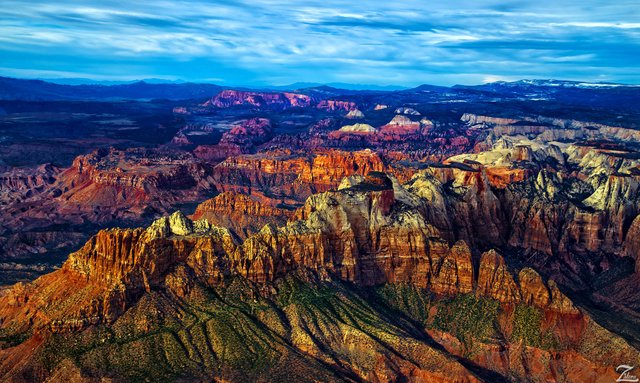
This is a most remarkable, iconic location that is utterly wondrous to behold, and even more so from this lofty view as seen from Where Eagles Fly… Zion National Park, Utah.
Taken while flying northwest bound across the southern part of the park this very rare image shows the park in its entirety from the south looking north.
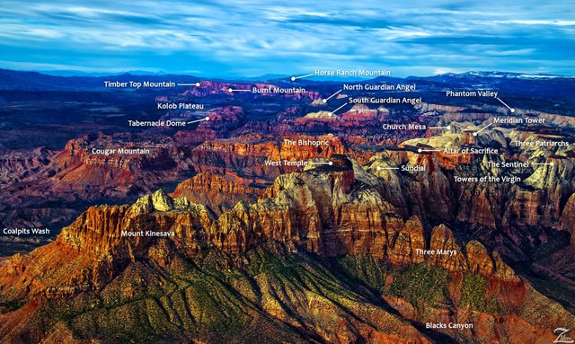
In the immediate foreground, the large mountainous formation running horizontally across the image is Mount Kinesava and along its top ridge is the Western Temple (in the middle) and the Altar of Sacrifice (to the immediate right of the Western Temple).
Because this is such an iconic location that so many have visited, I created a location map key that details the various famous landmark formations located within the park:
Be sure to click on the above images to see them full screen size.
Spread out across the Markagunt and Kolob plateaus, Zion is located at the intersection of three geographic provinces: Colorado Plateau, the Great Basin, and the Mojave Desert.
These otherworldly looking formations are the jagged edge of a huge area that has been twisted, uplifted, tilted, and eroded over time, forming a geological feature known as the Grand Staircase; a series of colorful cliffs stretching up out of the Grand Canyon all the way up to Bryce Canyon and over to Zion National Park.
These remarkable geological wonders have formed together over hundreds of millions of years. The bottom layer of rock at Bryce Canyon is the top layer at Zion, and the bottom layer at Zion is the top layer at the Grand Canyon. Zion began as a flat basin with an elevation near sea level around 240 million years ago.
As sands, gravels, and muds eroded from surrounding mountains, these materials ran into the basin and were deposited in layers. Each layer originated from a distinct source and so differs in thickness, mineral content, color, and eroded appearance. In this image you can see the stratified layers clearly along Mount Kinesava across to the Towers of the Virgin.
Then came the upheaval, covering a huge area from Zion all the way over to the Rocky Mountains, forces deep within the earth started to push the surface up in a very slow and relentless vertical hoisting of gigantic blocks of crust. The elevation around Zion rose from near sea level to as high as 10,000 feet above sea level over the course of 240 million years.
This uplift force is still happening. In 1992 a magnitude 5.8 earthquake created a landslide outside East Canyon on the south entrance to the park in Springdale. The lowest point of elevation is 3,666 ft (1,117 m) at Coalpits Wash and the highest is 8,726 ft (2,660 m) at Horse Ranch Mountain.
Originally this was known by the First Nations Southern Paiute tribes who lived here as either “Mukuntuweap” which means “straight canyon”, or “ I-oo-gune” or "like an arrow quiver". In 1909 the President of the United States, William Howard Taft, named the area a National Monument to protect the canyon, under the name of Mukuntuweap National Monument.
In 1918, however, the acting director of the newly created National Park Service changed the park's name to Zion, the name used by the Mormons. According to historian Hal Rothman: "The name change played to a prevalent bias of the time. Many believed that Spanish and Indian names would deter visitors who, if they could not pronounce the name of a place, might not bother to visit it.
The new name, Zion, had greater appeal to an ethnocentric audience." The United States Congress established the monument as a National Park on November 19, 1919.
I lensed this image while flying northwest over Shunesburg Mountain, south of The Watchmen formation on the southern border of Zion National Park.
From "Where Eagles Fly - The American Wilderness Expedition" my personal project of exploration in the North American Wilderness. I am on a mission to raise awareness of our Iconic Natural Heritage Treasures of North America.
Please re-steemit if you like what you see and want to help spread the word!
Yehaw!


Thx for sharing
I love America!
This is one of the most magnificent views I have ever seen. Your explanation of it's formation is truly enlightening. I will definitely upvote, resteem and follow you. A wonderful post.
Oh my god
I love mountains, they remind me of Bob Ross :)
This post is awesome and very ironic. I just made a post on my blog and I visited Zion, do you mind if I link this post to it? Here is the original post... https://steemit.com/travel/@maxy-hopkins/8-days-back-packing-part-1-vegas-and-the-drive
Ive been watching your posts for awhile now. I think they are amazing. You've mentioned selling framed copies. I looked at the videos of your custom framing. They look great, Very professional.
Have you ever considered a small paragraph inlay in the framing with some of the history and facts about the the area in the photo, like the museums have. Your discriptions are almost as intriguing as the photography.
Phenomenal lighting! And nice work labeling the skyline, I really enjoy hiking in Zion. Definitely recommend not going in peak season in summer--spring and fall is less crowded. Angels Landing is a lot more hair-raising when tourists who don't speak english are pushing past you on the narrows...
Stunning pictures of an amazing place. Thank you for the images and information.
Zion is a great place, I got to hike around in it one time. The location map was very helpful!