REMOTE SENSING (RS)
Source: [crisp.nus.edu.sg]
![[crisp.nus.edu.sg]](https://crisp.nus.edu.sg/~research/tutorial/infrared.gif)
Remote sensing is the process of detecting and monitoring a physical characteristics of an area by measuring its reflected and emitted radiation at a distance from the targeted area. Remote sensing is the art and science of making measurements of the earth using sensors on airplanes or satellites. Remote sensing is used in numerous fields, including geography, land surveying and most Earth Science disciplines.
Remote sensors collect data by detecting the energy that is reflected from Earth. These sensors can be on satellites or mounted on aircraft. These sensors collect data in the form of images and provide specialized capabilities for manipulating, analyzing, and visualizing those images. Remote sensed imagery is integrated within a GIS.
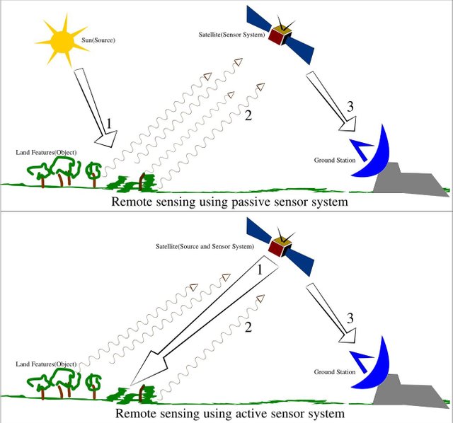
Types of Remote Sensing
 Source: [commons.wikimedia.org]
![[commons.wikimedia.org]](https://upload.wikimedia.org/wikipedia/commons/6/61/Remote_Sensing_Illustration.jpg)
There are two main types of remote sensing:
- Passive remote sensing
- Active remote sensing
Passive Sensors:
Passive sensors respond to external stimuli. They record natural energy that is reflected or emitted from the Earth's surface. The most common source of radiation detected by passive sensors is reflected sunlight. Examples of passive remote sensors include film photography, infrared, and radiometers.
Active Sensors:
Active sensors use internal stimuli to collect data about Earth. Active sensors emit energy in order to scan objects and areas whereupon a sensor then detects and measures the radiation that is reflected or backscattered from the target. RADAR is an example of active remote sensing where the time delay between emission and return is measured, establishing the location, height, speeds and direction of an object.
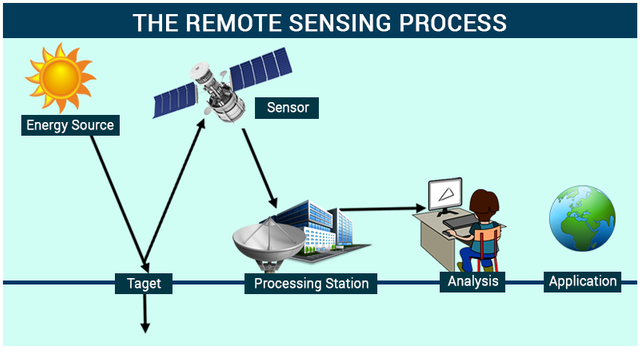
Process of Remote Sensing
 Source: [byjus.com]
![[byjus.com]](https://byjus.com/physics/wp-content/uploads/2016/06/23.png)
- Energy Source or Illumination:
The first requirement for remote sensing is to have an energy source which illuminates or provides electromagnetic energy to the target of interest. - Radiation and the Atmosphere:
As the energy travels from its source to the target, it will come in contact with and interact with the atmosphere it passes through. This interaction may take place a second time as the energy travels from the target to the sensor. - Interaction with the Target:
Once the energy makes its way to the target through the atmosphere, it interacts with the target depending on the properties of both the target and the radiation. - Recording of Energy by the Sensor:
After the energy has been scattered by, or emitted from the target, we require a sensor to collect and record the electromagnetic radiation. - Transmission, Reception, and Processing:
The energy recorded by the sensor has to be transmitted, often in electronic form, to a receiving and processing station where the data are processed. - Interpretation and Analysis:
The processed image is interpreted, visually and/or digitally or electronically, to extract information about the target, which was illuminated. - Application:
The final element of the remote sensing process is achieved when we apply the information we have been able to extract from the imagery about the target in order to better understand it, reveal some new information, or assist in solving a particular problem.
Advantages of Remote Sensing
Remote sensing makes it possible to collect data of dangerous or inaccessible areas. Special cameras collect remotely sensed images of the Earth, which help researchers "sense" things about the Earth. Some examples are:
- Cameras on satellites and airplanes take images of large areas on the Earth's surface, allowing us to see much more than we can standing on the ground.
- Sonar systems on ships can be used to create images of the ocean floor without needing to travel to the bottom of the ocean.
- Cameras on satellites can be used to make images of temperature changes in the oceans.
- Large forest fires can be mapped from space, allowing rangers to see a much larger area than from the ground.
- Tracking clouds to help predict the weather or watch erupting volcanoes, and help watch for dust storms.
- Tracking the growth of a city and changes in farmland or forests over several years or even decades.
- Mapping the ocean bottom - Discovery and mapping of the rugged topography of the ocean floor.
Remote sensing applications include monitoring deforestation in areas such as the Amazon Basin, glacial features in Arctic and Antarctic regions. Remote sensing replaces costly and slow data collection on the ground, ensuring in the process that areas or objects are not disturbed.
Congratulations! This post has been upvoted by @bdcommunity, requested by @reazuliqbal. It is a curation and support project for Bangladeshi content creators. You can support us by following our curation trail.
Please join us at the STEEM.com.bd Discord Channel.
Hi! I am a robot. I just upvoted you! I found similar content that readers might be interested in:
https://www.nrcan.gc.ca/earth-sciences/geomatics/satellite-imagery-air-photos/satellite-imagery-products/educational-resources/9363