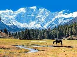
Nanga Parbat

The fairy ground is the middle ground between Nanga Parbat's high-rise peak and the Sarsal-e-Flak hills in the fairy habitat, the fairy or the ferry Medes, the region of Gilgit-Baltistan. Who is called in the name of 'Jait' in the Gilgit language, but due to the beauty of this place, German cuisine traveled to Nanga Parbat called it "Ferrari Medus" or fairy bird in 1950. It is also a base camp for travelers who visit Naga Parbat. In 1992, local people made camping sites for tourist facilities, which cover 9 acre area and are known as "Rai Kot Sarai". In 1995, the government was declared as "National Park" by Pakistan. This beautiful location is located at the height of 3300 meters from 9900 ft to sea level. Most foreign and foreign tourists sit in Islamabad from Gilgit Bus to travel to Raeet Kot, which is 540 km from Islamabad. Located at the distance. By coming to Roy Bridge's bridge, they sit down in some hotel sometime. From April to September, Roy Kot weather is very hot, worried by the hot winds coming from the rocky mountains and the villagers of Lu. Let's try to hurry. From here onwards, a rough way goes to Ferry Medous's height. It's a 16-kilometer long way, a tremendous way on the one side and deeper on the other side. Only on the way can be traveled through the jeep and only one vehicle can pass through it. From the River Coat to Tatutan, the Jupiter of the Second World War, which has only a capacity to accommodate only six presidents. . Jeep on this way is not even a common driver's bus, this work can be done by the driver of the live bus. The passenger 1000 to 150,000 rupees is called a traveler who looks very much like the distance of the passengers. This track is a rocky way between thousands of high-rise mountains. On the right side of the sky touching the sky, the Sanglakh mountain, a tropical stream flows around thousands of feet deep and on the other side, the chain of high mountains moves together. This strong jeep of ancient times hugged on the rocks to the heart, the passionate sky of the travelers. This track is counted in the world's awesome jeep tracks. When this jeep begins to climb from the highway to the track, first comes to a wide field, there are large stones in it, the jeep passes through them, but this open field ends soon. After that, vertical mounting begins, whose width is just as if a jeep is going on, then the person coming from the front or the cattle also has to pass through. If the other jeep comes from the direction of the fire, then one of them must stop traveling on one side in the reverse, and in the course of this journey, frequent jeep tires come on the extreme edge, under which there are deeper pitfalls in the drunk. During the journey, stones on the track come down under the tire and fall into the air below thousands of feet biting in the air. This jeep tracked the track Air Marshal Asghar Khan's younger brother Brigade Aslam Khan. He was the first commander of Gilgit Scouts. Nearly five feet wide, the road made with clay and rocks turns blindly in place of the road, due to land sliding, the road is blocked in several places, due to which the passengers cross the kiwak from the north to the north. I have to sit. On the one hand, a mountainous mountain is seen in the Nanga Prabhuti and any unexpected trips of the mountains, on the other side. This hill road in 2011 has been named "second deadly road of the world".
Jeep's path goes to Tat village. It is hot water in the villages, in the villages, a mountainous water is so hot that if it is kept for five minutes, then it boils, according to that village Is named. After the journey of more than two minutes from the Tat village, the road to the end of the road, there are five kilometers ahead of the road to foot pedestrians or even horse or mules can be taken from village, which is Rs 2500 per hundred See, but most tourists prefer traveling through tracking. This journey also leads to higher levels of rocketreast.