Doorjam Gulley Exit - An adventure in getting off trail - part 3📷
So, I posted all the pics from the main hike going UP doorjam mountain and Loader peak, but I had quite a different type of hike getting DOWN, which is normally the easy part of the day. Not this time!
Confessions of an adventurous hiker.
OK, so I will admit, my favorite kind of hike, is taking a route less traveled, no trail, unknown access, just do some bushwhacking and route finding and get where you need to go. However, I've ALWAYS done that on the way UP a mountain, since doing that going down a mountain can leave you getting stranded. In this case, ALMOST stranded, but a great adventure none the less, and so my kind of adventure in the end.
At the top of the mountain and alone the ridge, I kept my eye on an alternate gully exit that would take us down to the west and connect with another spot, Jura creek which I know well. I've done several other gulley exists in this area but never this particular one off the top of doorjam mountain.
However, I was up for the challenge with my buddies so we headed down. The route from what we could see looked pretty good, quite steep but winding out in a gulley below. We could see a small section of slot canyon but from the distance it looked like we could get through that and then it started to level out to the creek we knew, several kilometers further on.
So, alone the way, we found some icy falls, glittering in the sun and making for some nice photos.

The falls were tricky to get to, since everything was slippery and icy, but you know, worth the risk for the photos right?

The sun was just reaching in to hit the ice so it was just at the right time.

I love this one, with the larger ones.

So, we kept heading out and we came to a few small head walls where the creek was running that headed over a few more very small waterfalls. Not much to worry about, so we kept going, down the gully.

Nothing looked intimidating and so the gulley kept driving us down deeper into the valley.

You can see here, just how steep things are and its enough slope here we don't have a lot of options for side routes, but we didn't need them anyway. YET!

The gulley streem dried up (or went underground) in a lot of spots so much of this route was dry. The scenery was still quite beautiful, even though we had gotten into mostly rocks as we dropped lower.

I didn't take too many pics as things got steeper and steeper, but we ended up in a slot canyon that we went a long ways down and no way around on either side. Several small headwalls on it, seems like we would be stuck but we kept finding routes down them.
Until this one. Here we faced about 60m (200ft) of very steep slap that got slightly steeper and steeper as we went down it. It would have been likely 3 hrs to up and back over the mountain to get out and there where no other routes down, so we decided to try this slab and use the emergency 550 cord to assist on belay since the rock slab was just steep enough to slip the boots on, even in the best traction stance there is for slab, the crab walk.
So, I took lead and headed down, building body blocks and shoulder steps for the guys above wherever I could find a small crack or side to place my foot against. We slowly got lower and lower, short section at a time, till this last bit which was just too steep to make it down safely unassisted. We roped me up with a body belay and I headed down the last 40ft section. From there, I was able to catch the packs being lowered each next and then also help build foot steps and help guide the last guy on a rappel station using the rock as a rope anchor, just wrapped once around it. It was felt quite risky, but we did it safely and had no harm or issues at all. But it was certainly a spot where we were committed now to go down.

Thankfully this was the last tough section and we were able to scramble and hike out the rest of the short gully to the make creek we intended to intersect with. From there, it was easy, and I've been there many times, but never the gulley we descended. But, what an adventure! It took about an hour to make this final slab safely, but that was better than 3+ hours to go back up the mountain and down the normal route.

I certainly wouldn't go back for this route again, as if there had been any water on the rocks or rain, we couldn't have done it at all, or we'd have to have proper full length ropes and harness to do it safely if there were any bad weather. We had fun, survived without injury, made a fun story and some great photos and adventures, what else can I ask for?
I hope you enjoyed this trip report and series of photos, I know I did making it!
Really enjoyed your trip photos...this is true adventure...traveling concealed and mysterious places always gives me chills...the best part you completed this without any injuries :)
Thanks vj1309, great to have your comments. I did forget about one injury. I went blasting down a skree slope in the trees (I love to be on the edge of in/out of control on skree) and this time I lost my speed control, fell onto the skree and since I was going so fast with skree sliding below me, I lost control and kept slider about 30ft towards a dropoff ledge. I was able to hook a tree at the last minute with my arm to save from going over, and in the process, I had torn my thumb's fingernail in half and it ripped off part way. It was gushing blood and hurt good, but I was Lucky and Thankful to have a small injury, as it could have been much worse. I was laughing and smiling the whole way, and after a stop to dress the wound, gauz it (I always have first aid with me), we were off again. No big deal, but a big risky that time for sure! Just added to the adventure though.
oh yeah that's a lucky escape...anyways all's well that ends well.
:)
Very nice photo
Thanks nezaigor, glad to share them!
Great trip report and photos @unipsycho Upvote!)
Awesome, thanks so much!
Awesome trip man especially the photos are gold. Keep it up.
Thanks johnboi, its so fun capturing some of the moments on these trips, I'm glad you liked em!
Those icicles look like water stalactites.. you look like your having a great time
Nice pictures
Ya, that's true, they looked really really cool! Definitely had a great time, I always do though in the mountains!
meep
@unipsycho nice pic upvoted you
can you cjeck me out please
https://steemit.com/steemitphotochallenge/@diverse-thinker/steemitphotochallenge-43-entry-2
Woww amazing post
Wow what an adventure! Great!!!!!
550 paracord...oh yes I have done that too. Very, very dicey(it can't take much more than a tiny fall) and after I did it I began to carry 100ft of 8mm canyon rope on all my mountain bushwhacks (3 1/2 pounds not too bad). You are much farther down the climbing road than me of course, just amazing!:)
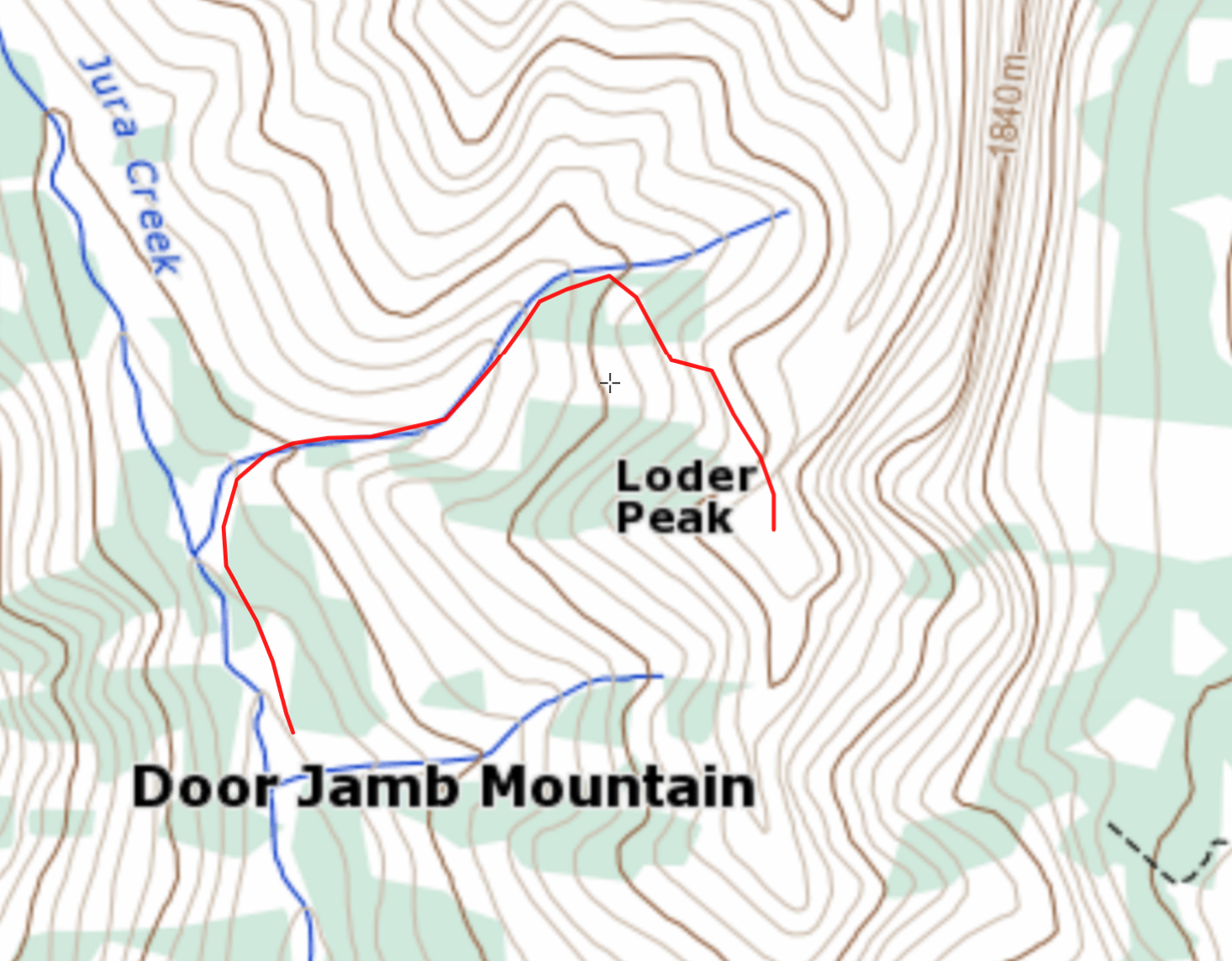
This looks like the route you took?
I do a fair bit of map recon before bushwhacks usually although I wing it too sometimes. I'm guessing you encountered the huge headwall near the bottom where the elevation line Vs sharply uphill which would be where the stream was back cutting. (sorry for this nerdy bit, I like to study a trip, especially afterward to understand the land better for the next time).
good question, not weird at all, I do the same in studying terrain maps from routes I've explore (or will). The red route you marked is the common exit from loader peak and eactually quite a good one. Its steep, but no bad cliffs or drops. I've done it before, which led me to think I could then also try the gully just south of loader, but still north of door jamb. The second blue streem on your map. Right down at the V, it had the drops we faced even though it didn't look quite as bad as the northern common route. However. haha.
Good idea on the 8mm rope, my buddy has an older climbing rope he's planning to upgrade, so we are going to cut a couple emergency sections from that to use/carry on questionable routes (and to get to/from caves of course that HAVE to be explored, haha)
Ah. More feet per mile won in the teror contest :). Those maps don't always help on cliffs. The lines fuzzing together thing isn't always there...or I don't notice lol.
Check! Caves must be explored:)
Wow nice picture!
Upvote♡ following you!
gulley streem..